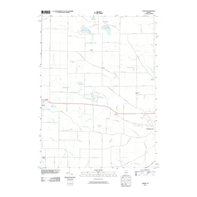
2010 Map of Lorane
USGS Topo · Published 2010About this map
Lorane sits at the heart of this Whitley County landscape, where a dense network of agricultural ditches and small glacial lakes defines the rural character of northern Indiana. This 2010 survey details the intricate water management system necessary for the region's farming, featuring named waterways such as McDonald Cunningham Ditch and Sattison Ditch. The map reveals the early 21st-century footprint of Larwill to the west and the western fringes of Columbia City to the east, connected by the historical corridor of Old Trail Rd and Bus 30 W. Genealogists will find several burial grounds preserved in the landscape, including Bethel Cemetery and Adams Cemetery. Distinctive landmarks like Motherwell Airport and the cluster of water bodies including Troy Cedar Lake, Wilson Lake, and Ice House Lake highlight the mix of private aviation and recreational water use that characterizes this part of the state.
Find a feature on this map
70 named features on this map. Tap any name to fly to it.
Don’t see what you’re looking for? This feature index may not catch every label — zoom into the map to look around manually.
Map Details
Editions of this 2010 Lorane Map
This is the sole edition of this map. No revisions or reprints were ever made.
Other maps of this area

1950 · Pierceton
USGS Topo · 1:24,000

1950 · North Webster
USGS Topo · 1:24,000

1951 · Ormas
USGS Topo · 1:24,000

1951 · Merriam
USGS Topo · 1:24,000

1953 · Fort Wayne
USGS Topo · 1:250,000

1955 · Columbia City
USGS Topo · 1:24,000

1956 · Fort Wayne
USGS Topo · 1:250,000

1956 · Lorane
USGS Topo · 1:24,000
1961 · Laud
USGS Topo · 1:24,000
1962 · South Whitley West
USGS Topo · 1:24,000