
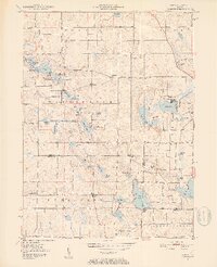
1951 Map of Ormas
USGS Topo · Published 1952About this map
The Tippecanoe River snakes through this glacial landscape on the border of Noble and Whitley Counties, connecting a dense network of kettle lakes including Bear Lake, High Lake, and the expansive Knapp Lake. In the early 1950s, this region was a tapestry of small agricultural communities and rural landmarks. The small settlement of Ormas sits centrally, while Etna anchors the southwestern corner. Local social life is mapped through several country churches like Stringtown Ch and Broadway Ch, along with the Washington Twp Sch. A notable leisure landmark is the Lakeview Speedway, situated just north of the river. The northern reaches include the Pioneer Trails Scout Reservation, highlighting the area's transition into a recreational landscape centered on its many named water bodies like Smalley Lake and Indian Lake.
Find a feature on this map
55 named features on this map. Tap any name to fly to it.
Don’t see what you’re looking for? This feature index may not catch every label — zoom into the map to look around manually.
Map Details
Editions of this 1951 Ormas Map
2 editions found
Other maps of this area

1950 · Pierceton
USGS Topo · 1:24,000

1950 · North Webster
USGS Topo · 1:24,000

1951 · Wawasee
USGS Topo · 1:24,000

1951 · Merriam
USGS Topo · 1:24,000

1953 · Fort Wayne
USGS Topo · 1:250,000

1955 · Columbia City
USGS Topo · 1:24,000

1956 · Fort Wayne
USGS Topo · 1:250,000

1956 · Ligonier
USGS Topo · 1:24,000

1956 · Lorane
USGS Topo · 1:24,000

1956 · Albion
USGS Topo · 1:24,000