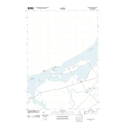
2011 Map of Louisville
USGS Topo · Published 2011About this map
The Saint Lawrence River serves as a major international boundary here, dividing the northern reaches of New York from Canada. This landscape is defined by its complex shoreline, where the Saint Lawrence Seaway passes through a series of shoals and islands including Wilson Hill Island, Nichols Hill Island, and Bradford Island. The interior is drained by the Grass River, which flows toward the settled area of Louisville. A network of local roads such as the Wilson Hill Cswy and Louisville-Wilson Hill Rd connect the riverfront points to the agricultural and residential centers. Genealogists may find interest in the Saint Lawrence Cemetery located near the riverbank, and the distinct community clusters at Louisville Corner and the primary village of Louisville. The presence of numerous shoals like Cat Island Shoal and Gooseneck Island Shoal highlights the navigational challenges inherent in this stretch of the river.
Find a feature on this map
29 named features on this map. Tap any name to fly to it.
Don’t see what you’re looking for? This feature index may not catch every label — zoom into the map to look around manually.
Map Details
Editions of this 2011 Louisville Map
This is the sole edition of this map. No revisions or reprints were ever made.
Other maps of this area

1905 · Waddington
USGS Topo · 1:62,500

1906 · Massena
USGS Topo · 1:62,500

1907 · Massena
USGS Topo · 1:62,500

1942 · Waddington
USGS Topo · 1:24,000

1942 · Chase Mills
USGS Topo · 1:24,000

1942 · Murphy Island
USGS Topo · 1:24,000

1942 · Norfolk
USGS Topo · 1:24,000

1942 · Massena
USGS Topo · 1:24,000
1943 · Waddington
USGS Topo · 1:31,680
1943 · Murphy Island
USGS Topo · 1:31,680