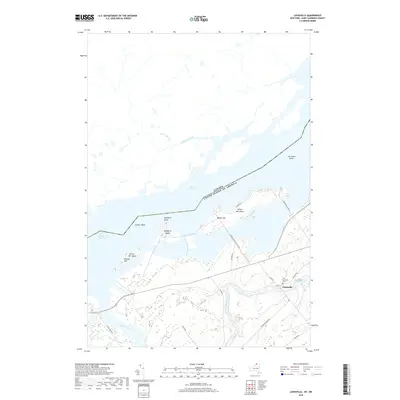
2019 Map of Louisville
USGS Topo · Published 2019About this map
The international border between Canada and the United States bisects Lake St. Lawrence, a massive reservoir created by the development of the Saint Lawrence Seaway. This modern survey documents the intricate shoreline and island systems that define the river valley today, including Wilson Hill Island and Nichols Hill Island. On the southern shore, the settlement of Louisville serves as a local hub near the confluence where the Grass River and McConnell Cr move toward the main channel. Further inland, the landscape is marked by a network of drainage systems like Coles Creek and Aultsville Creek, which reflect the hydraulic management of this transborder region. Local heritage is grounded in sites such as the Saint Lawrence Cem, positioned along the roads that connect these riverside communities.
Find a feature on this map
29 named features on this map. Tap any name to fly to it.
Don’t see what you’re looking for? This feature index may not catch every label — zoom into the map to look around manually.
Map Details
Editions of this 2019 Louisville Map
This is the sole edition of this map. No revisions or reprints were ever made.
Other maps of this area

1905 · Waddington
USGS Topo · 1:62,500

1906 · Massena
USGS Topo · 1:62,500

1907 · Massena
USGS Topo · 1:62,500

1942 · Waddington
USGS Topo · 1:24,000

1942 · Chase Mills
USGS Topo · 1:24,000

1942 · Murphy Island
USGS Topo · 1:24,000

1942 · Norfolk
USGS Topo · 1:24,000

1942 · Massena
USGS Topo · 1:24,000
1943 · Waddington
USGS Topo · 1:31,680
1943 · Murphy Island
USGS Topo · 1:31,680