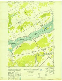
1946 Map of Louisville
USGS Topo · Published 1946About this map
The St Lawrence River serves as the international boundary on this 1946 chart, dividing the Dominion of Canada and the United States. Along the northern shore in Ontario, the settlements of Aultsville and East Williamsburg stand adjacent to the Canadian railroad line and the Farran Point Canal. This area is particularly significant for genealogists, as it captures the landscape before the massive St. Lawrence Seaway project altered the river's shoreline and displaced several of these communities. On the New York side, the town of Louisville sits at the confluence where the Grass River meets smaller tributaries like Coles Creek. Local landmarks such as Bradford Cem, Wright Cem Lawrence Cem, and several rural schoolhouses like School No 13 and School No 2 provide essential markers for tracing family history and former homesteads across St Lawrence Co.
Find a feature on this map
43 named features on this map. Tap any name to fly to it.
Don’t see what you’re looking for? This feature index may not catch every label — zoom into the map to look around manually.
Map Details
Editions of this 1946 Louisville Map
This is the sole edition of this map. No revisions or reprints were ever made.
Other maps of this area

1905 · Waddington
USGS Topo · 1:62,500

1906 · Massena
USGS Topo · 1:62,500

1907 · Massena
USGS Topo · 1:62,500

1942 · Waddington
USGS Topo · 1:24,000

1942 · Chase Mills
USGS Topo · 1:24,000

1942 · Murphy Island
USGS Topo · 1:24,000

1942 · Norfolk
USGS Topo · 1:24,000

1942 · Massena
USGS Topo · 1:24,000
1943 · Waddington
USGS Topo · 1:31,680
1943 · Murphy Island
USGS Topo · 1:31,680