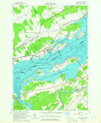
1964 Map of Louisville
USGS Topo · Published 1966About this map
Louisville and the international waters of the St Lawrence River define this mid-1960s border landscape. The map details a complex network of conservation areas and commemorative sites, notably the Crysler Farm Battlefield Park and the reconstructed heritage site of Upper Canada Village on the Canadian shore. In New York, the Wilson Hill State Fish and Game Management Area encompasses large island formations like Wilson Hill Island and Bradford Island. The interior is marked by the winding Grass River and local landmarks such as the Louisville Sch and St Lawrence Cem. This survey was conducted just after the completion of the St. Lawrence Seaway power project, reflecting the engineered shoreline and designated Seaway boundaries that transformed the region's geography and transport patterns.
Find a feature on this map
62 named features on this map. Tap any name to fly to it.
Don’t see what you’re looking for? This feature index may not catch every label — zoom into the map to look around manually.
Map Details
Editions of this 1964 Louisville Map
This is the sole edition of this map. No revisions or reprints were ever made.
Other maps of this area

1905 · Waddington
USGS Topo · 1:62,500

1906 · Massena
USGS Topo · 1:62,500

1907 · Massena
USGS Topo · 1:62,500

1942 · Waddington
USGS Topo · 1:24,000

1942 · Chase Mills
USGS Topo · 1:24,000

1942 · Murphy Island
USGS Topo · 1:24,000

1942 · Norfolk
USGS Topo · 1:24,000

1942 · Massena
USGS Topo · 1:24,000
1943 · Waddington
USGS Topo · 1:31,680
1943 · Murphy Island
USGS Topo · 1:31,680