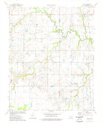
1974 Map of Lovell
USGS Topo · Published 1977About this map
Lovell sits at the eastern edge of this landscape where the Atchison Topeka and Santa Fe railroad cuts a north-south line through the plains. The region's economy is clearly defined by widespread Oil and Gas Fields, with numerous individual wells and drill holes dotting the sections. These industrial features contrast with the natural meandering paths of Skeleton Creek and Cottonwood Creek, which weave through the terrain alongside several smaller tributaries like Lyon Cr and Rock Creek.
Find a feature on this map
15 named features on this map. Tap any name to fly to it.
Don’t see what you’re looking for? This feature index may not catch every label — zoom into the map to look around manually.
Map Details
Editions of this 1974 Lovell Map
This is the sole edition of this map. No revisions or reprints were ever made.
Other maps of this area

1892 · Kingfisher
USGS Topo · 1:125,000

1893 · Lovell
USGS Topo · 1:62,500

1893 · Hennessey
USGS Topo · 1:62,500

1895 · Kingfisher
USGS Topo · 1:125,000

1954 · Oklahoma City
USGS Topo · 1:250,000

1955 · Enid
USGS Topo · 1:250,000

1956 · Hennessey
USGS Topo · 1:62,500

1957 · Oklahoma City
USGS Topo · 1:250,000

1958 · Enid
USGS Topo · 1:250,000

1963 · Oklahoma City
USGS Topo · 1:250,000