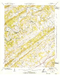
1940 Map of Lovell
USGS Topo · Published 1952About this map
Clinch River meanders through the heart of this East Tennessee landscape, creating dramatic loops at Freels Bend and Cruickshank Bend. Long, parallel ridges such as Copper Ridge and Blackoak Ridge dictate the settlement patterns of the 1940s, with rural communities like Solway and Ball Camp tucked into the fertile valleys. The map documents an era of river-based transport and traditional land use just before the massive industrial shifts of the mid-20th century. Local travel relied on features like Gallaher Ferry and crossings at Lee Ford, while the Louisville and Nashville railroad provided a vital connection to the broader region. Dozens of small landmarks, from Grigsby Chapel to the Hardin Valley Sch, anchor the social fabric of these ridge-and-valley neighborhoods.
Find a feature on this map
64 named features on this map. Tap any name to fly to it.
Don’t see what you’re looking for? This feature index may not catch every label — zoom into the map to look around manually.
Map Details
Editions of this 1940 Lovell Map
This is the sole edition of this map. No revisions or reprints were ever made.
Other maps of this area

1893 · Briceville
USGS Topo · 1:125,000

1895 · Loudon
USGS Topo · 1:125,000

1895 · Briceville
USGS Topo · 1:125,000

1896 · Briceville
USGS Topo · 1:125,000

1935 · Lenoir City
USGS Topo · 1:24,000

1935 · Bethel Valley
USGS Topo · 1:24,000

1935 · Bearden
USGS Topo · 1:24,000

1935 · Lovell
USGS Topo · 1:24,000

1936 · Louisville
USGS Topo · 1:24,000

1936 · Windrock
USGS Topo · 1:24,000