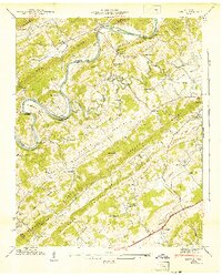
1941 Map of Lovell
USGS Topo · Published 1941About this map
Clinch River meanders sharply through the Tennessee landscape on this 1941 survey, defining a topography of alternating ridges and fertile valleys. The region is characterized by parallel formations including Pine Ridge, Raccoon Ridge, and Beaver Ridge, which channel drainage into Beaver Creek and Turkey Creek. This era of development is marked by the presence of the Louisville and Nashville RR and early thoroughfares like Buttermilk Road and the Lee Highway.
Find a feature on this map
59 named features on this map. Tap any name to fly to it.
Don’t see what you’re looking for? This feature index may not catch every label — zoom into the map to look around manually.
Map Details
Editions of this 1941 Lovell Map
This is the sole edition of this map. No revisions or reprints were ever made.
Other maps of this area

1893 · Briceville
USGS Topo · 1:125,000

1895 · Loudon
USGS Topo · 1:125,000

1895 · Briceville
USGS Topo · 1:125,000

1896 · Briceville
USGS Topo · 1:125,000

1935 · Lenoir City
USGS Topo · 1:24,000

1935 · Bethel Valley
USGS Topo · 1:24,000

1935 · Bearden
USGS Topo · 1:24,000

1935 · Lovell
USGS Topo · 1:24,000

1936 · Louisville
USGS Topo · 1:24,000

1936 · Windrock
USGS Topo · 1:24,000