1977 Map of Loving
USGS Topo · Published 1977About this map
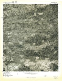
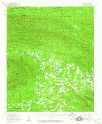
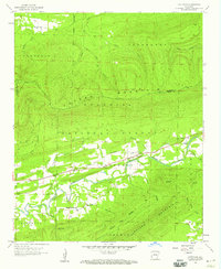
Loving, Oklahoma, sits at the northern edge of this late 1970s orthophotoquad, where the Poteau River winds through the borderlands near Arkansas. The landscape is dominated by the long, wooded ridge of Walker Mountain, which cuts a distinct diagonal across the center of the sheet. This aerial survey, produced by the Geological Survey in cooperation with the Soil Conservation Service, reveals a rural economy organized around mountain topography and creek bottoms. Clearings for small-scale agriculture and timber are visible along the drainage of Jones Creek and Haw Creek. To the south, the terrain descends toward the Black Fork, showing the transition from the high ridges of the Ouachita region to the fertile, low-lying valleys. The photograph captures the density of forest cover and the precise pattern of land use at Puryear, providing a grounded view of the region's topography before modern development altered these traditional boundaries.
Find a feature on this map
7 named features on this map. Tap any name to fly to it.
Don’t see what you’re looking for? This feature index may not catch every label — zoom into the map to look around manually.
Map Details
Editions of this 1977 Loving Map
This is the sole edition of this map. No revisions or reprints were ever made.
Other maps of this area

1887 · Poteau Mountain #2
USGS Topo · 1:62,500

1890 · Poteau Mountain
USGS Topo · 1:125,000

1899 · Poteau Mountain
USGS Topo · 1:125,000

1900 · Winding Stair
USGS Topo · 1:125,000
1909 · Winding Stair
USGS Topo · 1:125,000

1950 · Mcalester
USGS Topo · 1:250,000
1958 · Loving
USGS Topo · 1:24,000
1958 · Bates
USGS Topo · 1:62,500
1958 · Potter
USGS Topo · 1:62,500
1958 · Cauthron
USGS Topo · 1:24,000