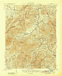
1946 Map of Lovingston
USGS Topo · Published 1946About this map
Lovingston serves as the focal point for this mid-century survey of Nelson County, where the eastern slopes of the Blue Ridge Mountains meet a network of productive river valleys. The landscape is defined by the Rockfish River and its numerous tributaries, which supported established settlements like Massies Mill, Greenfield, and Batesville. The map captures a moment when rural life centered on localized community hubs, evidenced by a high density of small educational and religious institutions such as Wintergreen School, Davis Creek School, and Oak Hill Church.
Find a feature on this map
98 named features on this map. Tap any name to fly to it.
Don’t see what you’re looking for? This feature index may not catch every label — zoom into the map to look around manually.
Map Details
Editions of this 1946 Lovingston Map
2 editions found

Other maps of this area

1892 · Buckingham
USGS Topo · 1:125,000

1892 · Harrisonburg
USGS Topo · 1:125,000

1894 · Staunton
USGS Topo · 1:125,000

1894 · Lexington
USGS Topo · 1:125,000

1929 · Covesville
USGS Topo · 1:62,500

1931 · University
USGS Topo · 1:62,500

1934 · Waynesboro
USGS Topo · 1:48,000

1935 · Amherst
USGS Topo · 1:48,000

1935 · Covesville
USGS Topo · 1:62,500

1935 · University
USGS Topo · 1:62,500