
Loading...
Loading map...2023 Map of Lowell
USGS Topo · Published 2023About this map
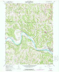
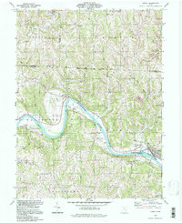
The Muskingum River dominates the central landscape of this Washington County survey, carving a broad valley that defines the local geography. Significant riparian features like Dana Island and the broad floodplains of Federal Bottom highlight the river's historic influence on settlement patterns. The village of Lowell and its neighboring Upper Lowell occupy the northern bank, where the topography transitions from the river's edge into the rising elevations of Dixon Ridge.
Find a feature on this map
140 named features on this map. Tap any name to fly to it.
Don’t see what you’re looking for? This feature index may not catch every label — zoom into the map to look around manually.
Map Details
Date Portrayed2023
Date Published2023
PublisherU.S. Geological Survey
Map TypeTopographic
Scale1:24000
Physical Dimensions24 x 29 inches
Editions of this 2023 Lowell Map
This is the sole edition of this map. No revisions or reprints were ever made.
Historical Maps of Upper Lowell Through Time
3 maps found
Featured Locations
Source Details
SourceU.S. Geological Survey
CopyrightPublic Domain