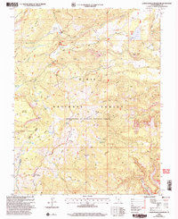
2002 Map of Lower Bowns Reservoir
USGS Topo · Published 2005About this map
Dixie National Forest dominates this high-altitude landscape, featuring a complex network of reservoirs and alpine lakes on the eastern slopes of Boulder Mountain. High-elevation pastures and flats, such as Wildcat Pasture and Sunflower Flat, reflect the area's long-standing use for summer grazing. The map documents significant water management infrastructure, most notably the Lower Bowns Reservoir and the Oak Creek Reservoir, which are vital to the downstream economy. This 2002 revision captures a transition in backcountry recreation, showing established routes like the Great Western Trail and the Ranger Trail alongside more primitive paths. The eastern portion of the map descends toward the drainage of Tantalus Creek, revealing the intricate topography of Stair Canyon and Big Ridge.
Find a feature on this map
51 named features on this map. Tap any name to fly to it.
Don’t see what you’re looking for? This feature index may not catch every label — zoom into the map to look around manually.
Map Details
Editions of this 2002 Lower Bowns Reservoir Map
This is the sole edition of this map. No revisions or reprints were ever made.
Other maps of this area

1885 · Fish Lake
USGS Topo · 1:250,000

1886 · Escalante
USGS Topo · 1:250,000

1896 · Fish Lake
USGS Topo · 1:250,000

1952 · Notom 3 SW
USGS Topo · 1:24,000

1952 · Notom 3 NW
USGS Topo · 1:24,000

1952 · Notom 4 NW
USGS Topo · 1:24,000

1952 · Notom 4 SW
USGS Topo · 1:24,000

1952 · Notom 3 SE
USGS Topo · 1:24,000

1952 · Notom 3 NE
USGS Topo · 1:24,000

1952 · Grover
USGS Topo · 1:62,500