
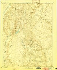
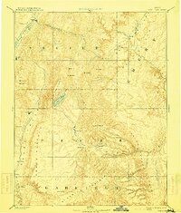
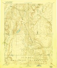
1896 Map of Fish Lake
USGS Topo · Published 1899About this map
Fish Lake sits at the heart of this high-altitude landscape, surrounded by the massive uplifts of the Fish Lake Plateau and the Awapa Plateau. The survey reveals a region of dramatic geological transitions, from the sharp breaks of the Water Pocket Flexure to the towering peaks of Thousand Lake M!. Human presence is concentrated in the river valleys, where small pioneer settlements like Thurber, Teardale, and Fremont follow the course of the Fremont River. To the west, the Sevier River corridor anchors the larger community of Salina and the nearby Willow Bend. This 1890s topography highlights the isolation of these high desert outposts, connected by early routes through Cousharam and Greenwich. The presence of Antimony in the southern reaches reflects the early mining interests that drew settlers into the remote canyons of the Aquarius Plateau.
Find a feature on this map
40 named features on this map. Tap any name to fly to it.
Don’t see what you’re looking for? This feature index may not catch every label — zoom into the map to look around manually.
Map Details
Editions of this 1896 Fish Lake Map
4 editions found
Other maps of this area

1885 · San Rafael
USGS Topo · 1:250,000

1885 · Manti
USGS Topo · 1:250,000

1885 · Beaver
USGS Topo · 1:250,000

1885 · Sevier Desert
USGS Topo · 1:250,000

1885 · Fish Lake
USGS Topo · 1:250,000

1886 · Kanab
USGS Topo · 1:250,000

1886 · Escalante
USGS Topo · 1:250,000

1886 · Henry Mountains
USGS Topo · 1:250,000

1886 · Price River
USGS Topo · 1:250,000

1892 · Henry Mountains
USGS Topo · 1:250,000