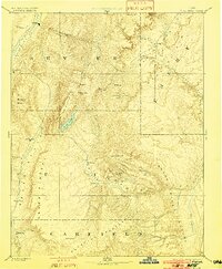
1896 Map of Fish Lake
USGS Topo · Published 1902About this map
Fish Lake sits at the heart of this high-elevation landscape, surrounded by the towering peaks of Mt Marvine and Mt Hilgard. This 1890s reconnaissance, conducted under J. W. Powell, reveals a series of isolated valley settlements linked by the Sevier River and its tributaries. The map details the transition from the irrigated fields of Salina and Glenwood to the more remote cattle-raising outposts of Rabbit Valley. Geologically, the survey captures the dramatic scale of the Water Pocket Flexure and the expansive Aquarius Plateau, illustrating how the massive volcanic and sedimentary formations dictated the early patterns of Mormon pioneer settlement in central Utah. From the ranching camps at Bean Spring to the small community of Cousharem, the document preserves the spatial layout of an era defined by high-desert agriculture and grazing.
Find a feature on this map
41 named features on this map. Tap any name to fly to it.
Don’t see what you’re looking for? This feature index may not catch every label — zoom into the map to look around manually.
Map Details
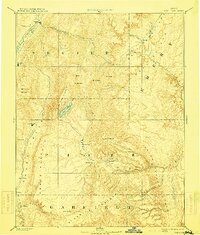
Editions of this 1896 Fish Lake Map
4 editions found

Other maps of this area

1885 · San Rafael
USGS Topo · 1:250,000

1885 · Manti
USGS Topo · 1:250,000

1885 · Beaver
USGS Topo · 1:250,000

1885 · Sevier Desert
USGS Topo · 1:250,000

1885 · Fish Lake
USGS Topo · 1:250,000

1886 · Kanab
USGS Topo · 1:250,000

1886 · Escalante
USGS Topo · 1:250,000

1886 · Henry Mountains
USGS Topo · 1:250,000

1886 · Price River
USGS Topo · 1:250,000

1892 · Henry Mountains
USGS Topo · 1:250,000