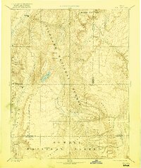
1896 Map of Fish Lake
USGS Topo · Published 1921About this map
Fish Lake sits atop the high Fish Lake Plateau, a focal point of this late 19th-century reconnaissance survey in central Utah. The landscape is defined by massive uplifted plateaus and deep drainage systems, including the Aquarius Plateau and Awapa Plateau. Small agrarian settlements are clustered in the fertile lowlands of Grass Valley and Rabbit Valley, where towns like Thurber and Fremont were establishing their footprint before the modern road systems were fully developed. To the east, the topography shifts dramatically toward the Water Pocket Curve and the San Rafael Swell, illustrating the transition from forested highlands to the arid canyon country. Surveyed by the Powell Survey, the map captures the early configuration of public lands across Fishlake National Forest and Powell National Forest, showing a network of creeks like Salina Creek and Muddy Creek that sustained these isolated communities.
Find a feature on this map
48 named features on this map. Tap any name to fly to it.
Don’t see what you’re looking for? This feature index may not catch every label — zoom into the map to look around manually.
Map Details
Editions of this 1896 Fish Lake Map
4 editions found

Other maps of this area

1885 · San Rafael
USGS Topo · 1:250,000

1885 · Manti
USGS Topo · 1:250,000

1885 · Beaver
USGS Topo · 1:250,000

1885 · Sevier Desert
USGS Topo · 1:250,000

1885 · Fish Lake
USGS Topo · 1:250,000

1886 · Kanab
USGS Topo · 1:250,000

1886 · Escalante
USGS Topo · 1:250,000

1886 · Henry Mountains
USGS Topo · 1:250,000

1886 · Price River
USGS Topo · 1:250,000

1892 · Henry Mountains
USGS Topo · 1:250,000