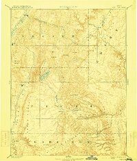
1896 Map of Fish Lake
USGS Topo · Published 1914About this map
Fish Lake sits at the heart of this late-19th-century reconnaissance of central Utah, marking a high-altitude anchor between the Sevier River and the high plateaus. The map documents a landscape of dramatic geological transitions, from the Coal Cliffs in the east to the Aquarius Plateau in the south. The settlement pattern follows the fertile valleys, with small hubs like Thurber and Fremont established in Rabbit Valley, while Salina and Glenwood flank the northern river corridor.
Find a feature on this map
49 named features on this map. Tap any name to fly to it.
Don’t see what you’re looking for? This feature index may not catch every label — zoom into the map to look around manually.
Map Details
Editions of this 1896 Fish Lake Map
4 editions found

Other maps of this area

1885 · San Rafael
USGS Topo · 1:250,000

1885 · Manti
USGS Topo · 1:250,000

1885 · Beaver
USGS Topo · 1:250,000

1885 · Sevier Desert
USGS Topo · 1:250,000

1885 · Fish Lake
USGS Topo · 1:250,000

1886 · Kanab
USGS Topo · 1:250,000

1886 · Escalante
USGS Topo · 1:250,000

1886 · Henry Mountains
USGS Topo · 1:250,000

1886 · Price River
USGS Topo · 1:250,000

1892 · Henry Mountains
USGS Topo · 1:250,000