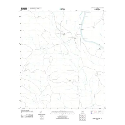
2011 Map of Lower Peach Tree
USGS Topo · Published 2011About this map
The Alabama River defines the eastern edge of this territory, where historic river navigation is marked by numerous riverfront landmarks including Ohio Bar, Montgomery Bar, and Poe Landing. In the river bend near Sakti Nákni Ontala, a series of landings like Henry Landing and Lower Peachtree Landing reflect the enduring importance of the waterway to local commerce. The settlement of Lower Peach Tree serves as a central hub, containing the Lower Peach Tree Post Office and the nearby Lower Peach Tree Cemetery. To the west, the community of Nettleboro sits along Silver Creek, while the interior landscape is etched with winding routes such as Cat Mash Rd and Old Line Rd, connecting family landmarks like the Kennedy Cemetery across a terrain drained by Cane Creek and Little Dry Creek.
Find a feature on this map
44 named features on this map. Tap any name to fly to it.
Don’t see what you’re looking for? This feature index may not catch every label — zoom into the map to look around manually.
Map Details
Editions of this 2011 Lower Peach Tree Map
This is the sole edition of this map. No revisions or reprints were ever made.
Other maps of this area

1953 · Andalusia
USGS Topo · 1:250,000

1957 · Andalusia
USGS Topo · 1:250,000

1972 · Franklin
USGS Topo · 1:24,000

1972 · Whatley
USGS Topo · 1:24,000

1972 · Chance
USGS Topo · 1:24,000

1973 · Coy
USGS Topo · 1:24,000

1973 · Fulton East
USGS Topo · 1:24,000

1973 · Hybart
USGS Topo · 1:24,000

1973 · Pine Hill
USGS Topo · 1:24,000

1973 · Thomasville
USGS Topo · 1:24,000