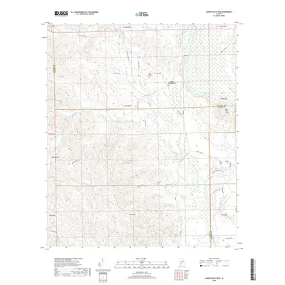
2018 Map of Lower Peach Tree
USGS Topo · Published 2018About this map
The Alabama River meanders through this section of the Black Belt, marking the border where Wilcox, Clarke, and Monroe counties meet. The settlement of Lower Peach Tree serves as a local focal point near the river's edge, characterized by a network of rural roads such as Black Jack Rd and St Thomas Ch Rd that lead toward the Lower Peach Tree Cem. To the west, the community of Nettleboro is situated along Nettlesboro Rd, surrounded by the winding tributaries of Silver Cr and Little Dry Cr. The landscape is defined by its hydrography, featuring the notable Ohio Bar in the river channel and numerous named branches like Holly Br and Cane Cr. Land use is further illustrated by local landmarks like the Kennedy Cem and the uniquely named area of Sakti Nakni Ontala in the eastern hills.
Find a feature on this map
51 named features on this map. Tap any name to fly to it.
Don’t see what you’re looking for? This feature index may not catch every label — zoom into the map to look around manually.
Map Details
Editions of this 2018 Lower Peach Tree Map
This is the sole edition of this map. No revisions or reprints were ever made.
Other maps of this area

1953 · Andalusia
USGS Topo · 1:250,000

1957 · Andalusia
USGS Topo · 1:250,000

1972 · Franklin
USGS Topo · 1:24,000

1972 · Whatley
USGS Topo · 1:24,000

1972 · Chance
USGS Topo · 1:24,000

1973 · Coy
USGS Topo · 1:24,000

1973 · Fulton East
USGS Topo · 1:24,000

1973 · Hybart
USGS Topo · 1:24,000

1973 · Pine Hill
USGS Topo · 1:24,000

1973 · Thomasville
USGS Topo · 1:24,000