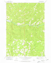
1972 Map of Lowman
USGS Topo · Published 1977About this map
Lowman serves as the central hub of this mountain landscape, situated at the confluence of the South Fork Payette River and several tributary drainages. The 1970s terrain is marked by a legacy of resource extraction and early forest management, evidenced by the Specimen Mine and Banner Mine, as well as a Sawmill located near the headwaters of Banner Creek. Outdoor recreation and conservation are well-established here, with the Lowman Ranger Station, Mountain View Campground, and the thermal waters of Kirkham Hot Springs providing focal points for visitors within the Boise National Forest. The topography is dominated by massive landforms such as Kirkham Ridge and Banner Ridge, while a network of jeep trails and a primary Logging Road indicate the active timber and surveying efforts of the era.
Find a feature on this map
38 named features on this map. Tap any name to fly to it.
Don’t see what you’re looking for? This feature index may not catch every label — zoom into the map to look around manually.
Map Details
Editions of this 1972 Lowman Map
This is the sole edition of this map. No revisions or reprints were ever made.
Other maps of this area

1891 · Bear Valley
USGS Topo · 1:125,000

1893 · Bear Valley
USGS Topo · 1:125,000

1894 · Idaho Basin
USGS Topo · 1:125,000

1894 · Rocky Bar
USGS Topo · 1:125,000

1909 · Garden Valley
USGS Topo · 1:125,000

1955 · Hailey
USGS Topo · 1:250,000

1957 · Challis
USGS Topo · 1:250,000

1959 · Hailey
USGS Topo · 1:250,000

1960 · Challis
USGS Topo · 1:250,000

1962 · Hailey
USGS Topo · 1:250,000