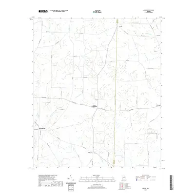
2020 Map of Lucile
USGS Topo · Published 2020About this map
Lucile and Jones Crossroads anchor this agricultural landscape in Miller and Early Counties, where the terrain is defined by a dense network of small drainages and springs. The map shows a region shaped by its water sources, including Howards Mill Cr and Fishpond Drain, which sustain the surrounding farmland. The settlement pattern is largely decentralized, with small communities like Killarney and Mayhaw situated along a grid of local roads such as Colquith Rd and Fryer Rd. Genealogy researchers may find interest in the location of Green Cem and family-named landmarks like Bethel Spring and Gilbert Lake. The division between the two counties is clearly marked by the W Early Co Line Rd, illustrating how administrative boundaries often follow or intersect these rural corridors.
Find a feature on this map
63 named features on this map. Tap any name to fly to it.
Don’t see what you’re looking for? This feature index may not catch every label — zoom into the map to look around manually.
Map Details
Editions of this 2020 Lucile Map
This is the sole edition of this map. No revisions or reprints were ever made.
Other maps of this area

1953 · Dothan
USGS Topo · 1:250,000

1954 · Dothan
USGS Topo · 1:250,000

1955 · Dothan
USGS Topo · 1:250,000

1970 · Gordon
USGS Topo · 1:24,000
1970 · Saffold
USGS Topo · 1:24,000

1970 · Columbia
USGS Topo · 1:24,000

1973 · Blakely South
USGS Topo · 1:24,000

1973 · Hentown
USGS Topo · 1:24,000

1974 · Donalsonville NE
USGS Topo · 1:24,000
1974 · Donalsonville East
USGS Topo · 1:24,000