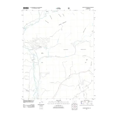
2011 Map of Ludwig Mountain
USGS Topo · Published 2011About this map
The Los Pinos River carves a deep path through this Colorado landscape, flanked by complex irrigation networks essential to the region's high-altitude ranching and agriculture. A series of engineered waterways, including the Thompson-Epperson Ditch, Los Pinos Ditch, and Wommer Ditch, demonstrate the intensive management of mountain runoff near the settlement of Vallecito. The presence of the Pine River Mine, Excelsior Mine, and Palmer Mine points to the area's history of mineral extraction, with mining claims established among the peaks of Ludwig Mountain and Shaefer Mountain. Modern residential developments like those around Lake Simpatico contrast with older traces of the land, such as the Old Cortez Trl, showing the shift from early resource extraction and transit to contemporary land use near the Vallecito Reservoir.
Find a feature on this map
54 named features on this map. Tap any name to fly to it.
Don’t see what you’re looking for? This feature index may not catch every label — zoom into the map to look around manually.
Map Details
Editions of this 2011 Ludwig Mountain Map
This is the sole edition of this map. No revisions or reprints were ever made.
Other maps of this area

1908 · Ignacio
USGS Topo · 1:125,000

1924 · Ignacio
USGS Topo · 1:125,000

1924 · Pagosa Springs
USGS Topo · 1:125,000

1927 · Pagosa Springs
USGS Topo · 1:125,000

1945 · Durango
USGS Topo · 1:250,000

1953 · Durango
USGS Topo · 1:250,000

1954 · Durango
USGS Topo · 1:250,000

1961 · Durango
USGS Topo · 1:250,000

1963 · Durango
USGS Topo · 1:250,000
1964 · Baldy Mountain
USGS Topo · 1:24,000