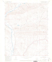
1964 Map of Ludwig Mountain
USGS Topo · Published 1968About this map
The Los Pinos River carves through this corner of the San Juan National Forest in southwestern Colorado, defining a landscape shaped by water management and high-altitude terrain. Irrigation is central to the valley's development, evidenced by an extensive network of gravity-fed water systems including the Farrell Ditch, Sullivan Ditch, and Thompson-Epperson Ditch which trace the contours along the river banks. These engineering feats speak to the ranching and agricultural history of the region below the rugged peaks.
Find a feature on this map
42 named features on this map. Tap any name to fly to it.
Don’t see what you’re looking for? This feature index may not catch every label — zoom into the map to look around manually.
Map Details
Editions of this 1964 Ludwig Mountain Map
This is the sole edition of this map. No revisions or reprints were ever made.
Other maps of this area

1908 · Ignacio
USGS Topo · 1:125,000

1924 · Ignacio
USGS Topo · 1:125,000

1924 · Pagosa Springs
USGS Topo · 1:125,000

1927 · Pagosa Springs
USGS Topo · 1:125,000

1945 · Durango
USGS Topo · 1:250,000

1953 · Durango
USGS Topo · 1:250,000

1954 · Durango
USGS Topo · 1:250,000

1961 · Durango
USGS Topo · 1:250,000

1963 · Durango
USGS Topo · 1:250,000
1964 · Baldy Mountain
USGS Topo · 1:24,000