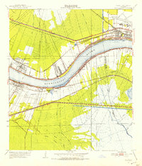
1951 Map of Luling
USGS Topo · Published 1953About this map
The Mississippi River defines the landscape of this riverfront corridor, where the 1951 revision shows a dense network of river-town settlements and industrial infrastructure. Communities like Kenner, Destrehan, and Luling line the banks, connected by the Airline Highway and a complex rail system including the Illinois Central Railroad and Texas and Pacific Railroad. A historical scar remains visible at the Davis Crevasse of 1884, marking a significant breach in the levee system that shaped the local drainage.
Find a feature on this map
40 named features on this map. Tap any name to fly to it.
Don’t see what you’re looking for? This feature index may not catch every label — zoom into the map to look around manually.
Map Details
Editions of this 1951 Luling Map
2 editions found
Other maps of this area

1891 · Hahnville
USGS Topo · 1:62,500

1891 · Spanish Fort
USGS Topo · 1:62,500

1891 · New Orleans
USGS Topo · 1:62,500

1892 · Bonnet Carre
USGS Topo · 1:62,500

1932 · New Orleans NW
USGS Topo · 1:31,680

1932 · New Orleans SW
USGS Topo · 1:31,680

1932 · Hahnville NW
USGS Topo · 1:31,680

1932 · Hahnville SW
USGS Topo · 1:31,680

1932 · Hahnville NE
USGS Topo · 1:31,680

1935 · Laplace
USGS Topo · 1:31,680