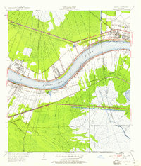
1951 Map of Luling
USGS Topo · Published 1958About this map
The Mississippi River winds through this mid-century landscape, anchoring a series of riverfront communities including Destrehan, St Rose, and Ama. A striking historical marker, the Davis Crevasse of 1884, remains visible on the west bank, testifying to the river's power before modern flood controls. This region is a complex web of water management and transportation, where the Illinois Central, Southern Pacific, and Texas and Pacific railroads intersect with early automobile routes like the Airline Highway.
Find a feature on this map
36 named features on this map. Tap any name to fly to it.
Don’t see what you’re looking for? This feature index may not catch every label — zoom into the map to look around manually.
Map Details
Editions of this 1951 Luling Map
2 editions found
Other maps of this area

1891 · Hahnville
USGS Topo · 1:62,500

1891 · Spanish Fort
USGS Topo · 1:62,500

1891 · New Orleans
USGS Topo · 1:62,500

1892 · Bonnet Carre
USGS Topo · 1:62,500

1932 · New Orleans NW
USGS Topo · 1:31,680

1932 · New Orleans SW
USGS Topo · 1:31,680

1932 · Hahnville NW
USGS Topo · 1:31,680

1932 · Hahnville SW
USGS Topo · 1:31,680

1932 · Hahnville NE
USGS Topo · 1:31,680

1935 · Laplace
USGS Topo · 1:31,680