
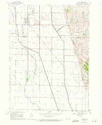
1964 Map of Luton
USGS Topo · Published 1966About this map
Luton and Owego anchor this agricultural landscape in Woodbury County, where the flat alluvial plains of the Missouri River valley meet the rising loess hills. The geography is defined by extensive drainage infrastructure, notably the Farmers Ditch and Garretson Ditch, which redirect water across the townships of Grange and Sloan. This 1964 survey captures the region's critical dependence on the Chicago Milwaukee St Paul and Pacific railroad, which cuts a straight diagonal line across the grid-patterned sections to serve these small shipping points. To the east, the terrain shifts abruptly as the drainage of Camp Creek and Wolf Creek enters more dissected topography. The presence of Gravel Pits near the hills indicates the local extraction industry that supported the construction of the area's rural road network, including Route 75.
Find a feature on this map
12 named features on this map. Tap any name to fly to it.
Don’t see what you’re looking for? This feature index may not catch every label — zoom into the map to look around manually.
Map Details
Editions of this 1964 Luton Map
This is the sole edition of this map. No revisions or reprints were ever made.
Other maps of this area

1955 · Sioux City
USGS Topo · 1:250,000

1958 · Sioux City
USGS Topo · 1:250,000

1959 · Sioux City
USGS Topo · 1:250,000

1964 · Sergeant Bluff
USGS Topo · 1:24,000

1964 · Lawton
USGS Topo · 1:24,000

1964 · Climbing Hill
USGS Topo · 1:24,000

1964 · Moville
USGS Topo · 1:24,000

1964 · Salix
USGS Topo · 1:24,000

1969 · Albaton
USGS Topo · 1:24,000
1969 · Hornick
USGS Topo · 1:24,000