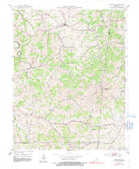
1953 Map of Mackville
USGS Topo · Published 1991About this map
Mackville serves as the central hub of this agricultural landscape in Washington County, situated at the junction of several rural routes during the early 1950s. The terrain is deeply carved by the Beech Fork and its numerous tributaries, including Long Lick Creek and Tick Creek, which dictate the placement of early settlements and family farms. Genealogical interest is high throughout the quadrangle, with numerous family burial grounds such as McMullin Cem, Cull Cem, and Cocanougher Cem dotting the ridges and hillsides. Small communities like Jenkinsville, Texas, and Pottsville anchor the surrounding countryside, often centered around local landmarks like Beech Grove Ch and Wesley Chapel. The map also captures the complex intersection of four Kentucky counties, illustrating the jagged boundaries where Washington, Mercer, Boyle, and Marion counties converge amidst the winding creek beds.
Find a feature on this map
36 named features on this map. Tap any name to fly to it.
Don’t see what you’re looking for? This feature index may not catch every label — zoom into the map to look around manually.
Map Details
Editions of this 1953 Mackville Map
2 editions found
Other maps of this area

1905 · Harrodsburg
USGS Topo · 1:125,000

1952 · Perryville
USGS Topo · 1:24,000

1952 · Cornishville
USGS Topo · 1:24,000

1952 · Parksville
USGS Topo · 1:24,000

1953 · Mackville
USGS Topo · 1:24,000

1953 · Brush Grove
USGS Topo · 1:24,000

1953 · Gravel Switch
USGS Topo · 1:24,000

1953 · Lebanon East
USGS Topo · 1:24,000

1953 · Cardwell
USGS Topo · 1:24,000

1953 · Springfield
USGS Topo · 1:24,000