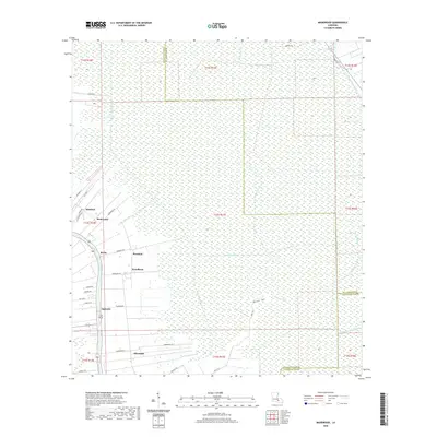
2020 Map of Madewood
USGS Topo · Published 2020About this map
Bayou Lafourche anchors this stretch of Assumption Parish, where a dense network of settlements traces the historic corridor of the waterway. Linear communities such as Madewood, Rosedale, and Ingleside are concentrated along the western edge, reflecting a land-use pattern dictated by the natural levees. East of these settlements, the landscape transforms into a complex drainage system of canals and bayous, including Baker Canal East and Bayou Verret, which penetrate the expansive lowlands. The presence of numerous named roads like Rosedale Rd and Woodlawn Rd suggests the enduring footprint of former plantation boundaries. Near the southern border, the settlement of Albemarle and the winding Bayou Petit Chackbay mark the transition toward the wetlands of Lafourche Parish, illustrating how regional hydrology continues to shape Louisiana's parish lines and habitable spaces.
Find a feature on this map
48 named features on this map. Tap any name to fly to it.
Don’t see what you’re looking for? This feature index may not catch every label — zoom into the map to look around manually.
Map Details
Editions of this 2020 Madewood Map
This is the sole edition of this map. No revisions or reprints were ever made.
Other maps of this area

1892 · Donaldsonville
USGS Topo · 1:62,500

1892 · Thibodaux
USGS Topo · 1:62,500

1927 · Thibodaux NW
USGS Topo · 1:31,680

1932 · Thibodaux NE
USGS Topo · 1:31,680

1932 · Thibodaux SE
USGS Topo · 1:31,680

1932 · Thibodaux SW
USGS Topo · 1:31,680

1936 · White Castle
USGS Topo · 1:62,500

1938 · Labadieville
USGS Topo · 1:24,000
1938 · Lafourche
USGS Topo · 1:24,000

1939 · Donaldsonville
USGS Topo · 1:62,500