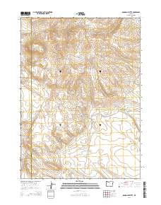
2014 Map of Mahogany Butte
USGS Topo · Published 2014About this map
Mahogany Butte and the surrounding high desert terrain define this corner of the state, where the boundary between Lake County and Harney County runs North-South through a landscape of volcanic features and vital water sources. This 2014 survey captures a region defined by its topography rather than its towns, centered on Mahogany Mtn and the strategic Shirks Lookout. The distribution of named water points like Buckaroo Spring, Dropoff Waterhole, and Rose Brief Spring indicates the critical importance of reliable hydrology for land management in this arid environment. Roads such as Mahogany Mountain Rd and Buckaroo Pass Rd navigate the drainages of West Road Gulch and East Road Gulch, providing access to high-elevation grazing and monitoring points. The southern portion of the map levels out into the broad expanse of Ryegrass Valley, accessible via Buckaroo Pass.
Find a feature on this map
30 named features on this map. Tap any name to fly to it.
Don’t see what you’re looking for? This feature index may not catch every label — zoom into the map to look around manually.
Map Details
Editions of this 2014 Mahogany Butte Map
This is the sole edition of this map. No revisions or reprints were ever made.
Other maps of this area

1955 · Adel
USGS Topo · 1:250,000

1957 · Adel
USGS Topo · 1:250,000

1958 · Adel
USGS Topo · 1:250,000

1962 · Adel
USGS Topo · 1:250,000

1971 · Fish Fin Rim
USGS Topo · 1:24,000
1971 · Acty Mountain NW
USGS Topo · 1:24,000

1971 · Beatys Butte
USGS Topo · 1:24,000

1971 · Surveyors Lake
USGS Topo · 1:24,000

1971 · Mahogany Butte
USGS Topo · 1:24,000
1971 · Beatys Butte NW
USGS Topo · 1:24,000