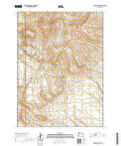
2020 Map of Mahogany Butte
USGS Topo · Published 2020About this map
Mahogany Butte and Mahogany Mtn anchor this high-elevation landscape along the boundary of Harney and Lake Counties. The terrain is defined by a series of critical water sources essential for livestock and wildlife in the high desert, including Buckaroo Spring, Lick Spring, and the Dropoff Waterhole. Human presence is marked primarily by rugged transit routes such as Mahogany Mountain Rd and Buckaroo Pass Rd, which navigate the steep shifts in elevation between Ryegrass Valley and prominent summits like Shirks Lookout. This area serves as a transit corridor for those moving between the basins, evidenced by the named passes and the network of springs like Sunrise Spring and North Highland Spring that dot the drainages of East Road Gulch and West Road Gulch.
Find a feature on this map
27 named features on this map. Tap any name to fly to it.
Don’t see what you’re looking for? This feature index may not catch every label — zoom into the map to look around manually.
Map Details
Editions of this 2020 Mahogany Butte Map
This is the sole edition of this map. No revisions or reprints were ever made.
Other maps of this area

1955 · Adel
USGS Topo · 1:250,000

1957 · Adel
USGS Topo · 1:250,000

1958 · Adel
USGS Topo · 1:250,000

1962 · Adel
USGS Topo · 1:250,000

1971 · Fish Fin Rim
USGS Topo · 1:24,000
1971 · Acty Mountain NW
USGS Topo · 1:24,000

1971 · Beatys Butte
USGS Topo · 1:24,000

1971 · Surveyors Lake
USGS Topo · 1:24,000

1971 · Mahogany Butte
USGS Topo · 1:24,000
1971 · Beatys Butte NW
USGS Topo · 1:24,000