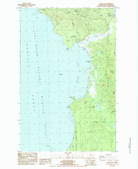
1984 Map of Makah Bay
USGS Topo · Published 1984About this map
The northwest tip of the contiguous United States comes into sharp focus through Cape Flattery and the surrounding coastline of the Makah Indian Reservation. This mid-1980s provisional map highlights a landscape defined by the intersection of tribal land and federal jurisdiction, featuring the Makah Air Force Station on the heights above Makah Bay. The coastal geography is intricate, marked by hazardous offshore features like rocks, reefs, and the specific site of Meg's Shipwreck near Portage Head.
Find a feature on this map
52 named features on this map. Tap any name to fly to it.
Don’t see what you’re looking for? This feature index may not catch every label — zoom into the map to look around manually.
Map Details
Editions of this 1984 Makah Bay Map
This is the sole edition of this map. No revisions or reprints were ever made.
Other maps of this area

1935 · Ozette Lake
USGS Topo · 1:62,500

1938 · Cape Flattery
USGS Topo · 1:62,500

1942 · Ozette Lake
USGS Topo · 1:62,500

1953 · Cape Flattery
USGS Topo · 1:250,000

1956 · Ozette Lake
USGS Topo · 1:62,500
1957 · Cape Flattery
USGS Topo · 1:62,500

1963 · Cape Flattery
USGS Topo · 1:250,000

1984 · Umbrella Creek
USGS Topo · 1:24,000
1984 · Ozette
USGS Topo · 1:24,000
1984 · Neah Bay
USGS Topo · 1:24,000