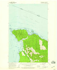
1957 Map of Cape Flattery
USGS Topo · Published 1959About this map
The northwest tip of the contiguous United States, centered on the Makah Indian Reservation, shows a landscape where maritime defense and indigenous territory meet. Military and federal installations like the Makah Air Force Station and a Coast Guard Station at Neah Bay overlook the vital shipping lanes of the Strait of Juan de Fuca. The map details the rugged Pacific coastline, from the iconic Tatoosh Island and its surrounding rocks like Fuca Pillar to the southern Portage Head. Inland, the terrain is defined by dramatic elevations such as Bahokus Peak and the drainage networks of the Waatch River and Sooes River. The presence of an Old Grade and RR Grade suggests the region's historic reliance on timber extraction or early logistical networks through the dense coastal forests.
Find a feature on this map
83 named features on this map. Tap any name to fly to it.
Don’t see what you’re looking for? This feature index may not catch every label — zoom into the map to look around manually.
Map Details
Editions of this 1957 Cape Flattery Map
2 editions found
Other maps of this area

1935 · Clallam
USGS Topo · 1:62,500

1935 · Ozette Lake
USGS Topo · 1:62,500

1935 · Lake Pleasant
USGS Topo · 1:62,500

1938 · Cape Flattery
USGS Topo · 1:62,500

1942 · Clallam
USGS Topo · 1:62,500

1942 · Ozette Lake
USGS Topo · 1:62,500

1942 · Lake Pleasant
USGS Topo · 1:62,500

1953 · Cape Flattery
USGS Topo · 1:250,000

1956 · Ozette Lake
USGS Topo · 1:62,500

1957 · Lake Pleasant
USGS Topo · 1:62,500