
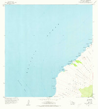
1959 Map of Makalawena
USGS Topo · Published 1960About this map
Lava Flow of 1801 dominates the coastal landscape of North Kona, revealing the raw volcanic geography of the Island of Hawaii prior to modern resort development. This 1959 field check records a series of traditional coastal sites and bays, including Kukio Bay, Kahoiawa Bay, and Mahaiula Bay. The settlement of Makalawena is noted alongside several Graves and a Lava Tube, suggesting a history of habitation tied closely to the shoreline and the brackish ponds of Awakee and Maniniowali.
Find a feature on this map
40 named features on this map. Tap any name to fly to it.
Don’t see what you’re looking for? This feature index may not catch every label — zoom into the map to look around manually.
Map Details
Editions of this 1959 Makalawena Map
2 editions found
Other maps of this area

1928 · Puako
USGS Topo · 1:62,500

1928 · Kailua
USGS Topo · 1:62,500

1954 · Hawaii North
USGS Topo · 1:250,000

1959 · Hawaii North
USGS Topo · 1:250,000

1959 · Kiholo
USGS Topo · 1:24,000
1959 · Anaehoomalu
USGS Topo · 1:24,000

1959 · Keahole Point
USGS Topo · 1:24,000

1959 · Kailua
USGS Topo · 1:24,000

1961 · Hawaii North
USGS Topo · 1:250,000

1975 · Hawaii
USGS Topo · 1:250,000