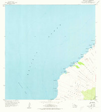
1959 Map of Makalawena
USGS Topo · Published 1973About this map
The Lava Flow of 1801 dominates this arid coastal landscape along the North Kona District, where hardened volcanic fields meet the Pacific Ocean. This survey reveals a sparsely populated shoreline defined by a series of bays including Kukio Bay, Kua Bay, and Makalawena Bay. Small settlements like Mahaiula and Kukio sit near the coast, connected primarily by a network of foot trails and jeep trails that navigate the complex geology of the Makalawena and Awakee lands.
Find a feature on this map
43 named features on this map. Tap any name to fly to it.
Don’t see what you’re looking for? This feature index may not catch every label — zoom into the map to look around manually.
Map Details
Editions of this 1959 Makalawena Map
2 editions found
Other maps of this area

1928 · Puako
USGS Topo · 1:62,500

1928 · Kailua
USGS Topo · 1:62,500

1954 · Hawaii North
USGS Topo · 1:250,000

1959 · Hawaii North
USGS Topo · 1:250,000

1959 · Kiholo
USGS Topo · 1:24,000
1959 · Anaehoomalu
USGS Topo · 1:24,000

1959 · Makalawena
USGS Topo · 1:24,000

1959 · Keahole Point
USGS Topo · 1:24,000

1959 · Kailua
USGS Topo · 1:24,000

1961 · Hawaii North
USGS Topo · 1:250,000