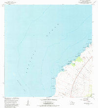
1982 Map of Makalawena
USGS Topo · Published 1984About this map
The Lava Flow of 1801 dominates this coastal landscape along the North Kona District, marking a distinct geological era where volcanic activity met the Pacific Ocean. This 1982 revision captures a transition point for the shoreline, where small coastal settlements like Makalawena and Mahaiula are reachable only by unimproved dirt roads. The map reveals a series of intricate bays and points, including Kukio Bay and Kua Bay, interspersed with archaeological and cultural markers such as Graves and a Cem near the coast. The presence of the Opaeula Pond suggests a unique brackish environment between the stark lava fields and the sea. For those tracing historical land divisions, the map clearly delineates traditional areas like Makala Wena and Maniniowali, providing a detailed look at the land's character before modern development changed the accessibility of these remote North Kona beaches.
Find a feature on this map
41 named features on this map. Tap any name to fly to it.
Don’t see what you’re looking for? This feature index may not catch every label — zoom into the map to look around manually.
Map Details
Editions of this 1982 Makalawena Map
2 editions found
Other maps of this area

1928 · Puako
USGS Topo · 1:62,500

1928 · Kailua
USGS Topo · 1:62,500

1954 · Hawaii North
USGS Topo · 1:250,000

1959 · Hawaii North
USGS Topo · 1:250,000

1959 · Kiholo
USGS Topo · 1:24,000
1959 · Anaehoomalu
USGS Topo · 1:24,000

1959 · Makalawena
USGS Topo · 1:24,000

1959 · Keahole Point
USGS Topo · 1:24,000

1959 · Kailua
USGS Topo · 1:24,000

1961 · Hawaii North
USGS Topo · 1:250,000