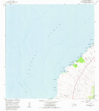
1982 Map of Makalawena
USGS Topo · Published 1982About this map
The Lava Flow of 1801 dominates this coastal landscape on the Island of Hawaii, reaching down to the North Kona shoreline across lands known as Kaulana and Makalawena. This arid, volcanic terrain is defined by its series of bays and inlets, from Kukio Bay in the north to Mahaiula Bay in the south, connected only by unimproved four-wheel drive tracks.
Find a feature on this map
43 named features on this map. Tap any name to fly to it.
Don’t see what you’re looking for? This feature index may not catch every label — zoom into the map to look around manually.
Map Details
Editions of this 1982 Makalawena Map
2 editions found
Other maps of this area

1928 · Puako
USGS Topo · 1:62,500

1928 · Kailua
USGS Topo · 1:62,500

1954 · Hawaii North
USGS Topo · 1:250,000

1959 · Hawaii North
USGS Topo · 1:250,000

1959 · Kiholo
USGS Topo · 1:24,000
1959 · Anaehoomalu
USGS Topo · 1:24,000

1959 · Makalawena
USGS Topo · 1:24,000

1959 · Keahole Point
USGS Topo · 1:24,000

1959 · Kailua
USGS Topo · 1:24,000

1961 · Hawaii North
USGS Topo · 1:250,000