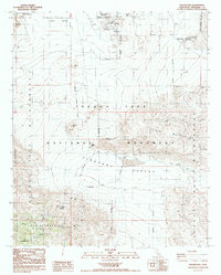
1988 Map of Malapai Hill
USGS Topo · Published 1988About this map
Malapai Hill rises as a prominent landmark in this desert terrain, surveyed just before the 1990s within the Joshua Tree National Monument. The landscape is defined by its water management and mining history, featuring essential water sources like Squaw Tank, Ivanpah Tank, and Twin Tanks that served travelers and livestock in an arid environment. The transition from high desert valleys to steep ridgelines is marked by the Hexie Mountains and the Little San Bernardino Mts.
Find a feature on this map
27 named features on this map. Tap any name to fly to it.
Don’t see what you’re looking for? This feature index may not catch every label — zoom into the map to look around manually.
Map Details
Editions of this 1988 Malapai Hill Map
This is the sole edition of this map. No revisions or reprints were ever made.
Other maps of this area

1942 · Amboy
USGS Topo · 1:250,000

1943 · Amboy
USGS Topo · 1:250,000

1943 · Pinkham Well
USGS Topo · 1:62,500

1944 · Pinkham Well
USGS Topo · 1:62,500

1944 · Pinyon Well
USGS Topo · 1:62,500

1947 · Santa Ana
USGS Topo · 1:250,000

1949 · Santa Ana
USGS Topo · 1:250,000

1953 · San Bernardino
USGS Topo · 1:250,000

1954 · Salton Sea
USGS Topo · 1:250,000

1954 · Needles
USGS Topo · 1:250,000