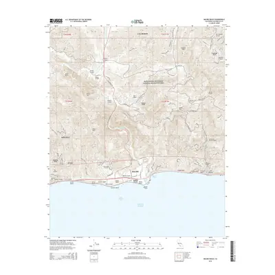
2015 Map of Malibu Beach
USGS Topo · Published 2015About this map
Malibu and its surrounding canyons are documented here during a period of sustained coastal development and conservation. The landscape is defined by the steep transition from the peaks of the Santa Monica Mountains National Recreation Area, including Calabasas Peak and Saddle Peak, down to the Pacific Ocean. Residential enclaves such as Monte Nido, Malibu Bowl, and El Nido are tucked into the drainages of the Malibu Canyon Road corridor, while the prominent campus of Pepperdine University overlooks the shoreline near Malibu Bluffs. Along the coast, famous stretches like Carbon Beach and La Costa Beach sit adjacent to the natural drainage of Malibu Lagoon. Further inland, the map captures the suburban fringes of Calabasas and the rural character of areas like Stokes Canyon and Liberty Canyon, illustrating the complex wildland-urban interface characteristic of this era in Los Angeles County.
Find a feature on this map
55 named features on this map. Tap any name to fly to it.
Don’t see what you’re looking for? This feature index may not catch every label — zoom into the map to look around manually.
Map Details
Editions of this 2015 Malibu Beach Map
This is the sole edition of this map. No revisions or reprints were ever made.
Other maps of this area

1900 · Triunfo Pass
USGS Topo · 1:62,500

1903 · Calabasas
USGS Topo · 1:62,500

1903 · Camulos
USGS Topo · 1:125,000

1921 · Triunfo Pass
USGS Topo · 1:62,500

1928 · Dry Canyon
USGS Topo · 1:24,000
1929 · Dry Canyon
USGS Topo · 1:24,000

1929 · Vejor
USGS Topo · 1:24,000

1929 · Solstice Canyon
USGS Topo · 1:24,000
1932 · Las Flores
USGS Topo · 1:24,000

1932 · Seminole
USGS Topo · 1:24,000
Featured Places
- Calabasas, CA
- Malibu, CA
- Unincorporated Santa Monica Mountains, CA
- Monte Nido, Unincorporated Santa Monica Mountains
- Crater Camp, Unincorporated Santa Monica Mountains