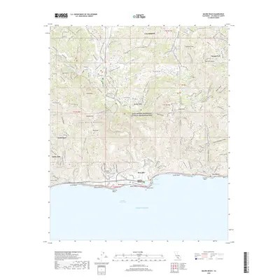
2018 Map of Malibu Beach
USGS Topo · Published 2018About this map
The Santa Monica Mountains National Recreation Area dominates this coastal landscape, where the steep canyons of the transverse ranges meet the Pacific Ocean. This survey details the complex interface of natural topography and late-20th-century development, anchored by the Pepperdine Univ Malibu Campus and the coastal settlement of Malibu. The map reveals a dense network of fire roads and recreational paths, such as the Liberty Canyon Fire Road and Phantom Trail, which traverse the high ridges of Saddle Peak and McAuley Peak.
Find a feature on this map
131 named features on this map. Tap any name to fly to it.
Don’t see what you’re looking for? This feature index may not catch every label — zoom into the map to look around manually.
Map Details
Editions of this 2018 Malibu Beach Map
This is the sole edition of this map. No revisions or reprints were ever made.
Other maps of this area

1900 · Triunfo Pass
USGS Topo · 1:62,500

1903 · Calabasas
USGS Topo · 1:62,500

1903 · Camulos
USGS Topo · 1:125,000

1921 · Triunfo Pass
USGS Topo · 1:62,500

1928 · Dry Canyon
USGS Topo · 1:24,000
1929 · Dry Canyon
USGS Topo · 1:24,000

1929 · Vejor
USGS Topo · 1:24,000

1929 · Solstice Canyon
USGS Topo · 1:24,000
1932 · Las Flores
USGS Topo · 1:24,000

1932 · Seminole
USGS Topo · 1:24,000
Featured Places
- Calabasas, CA
- Malibu, CA
- Unincorporated Santa Monica Mountains, CA
- Monte Nido, Unincorporated Santa Monica Mountains
- Crater Camp, Unincorporated Santa Monica Mountains