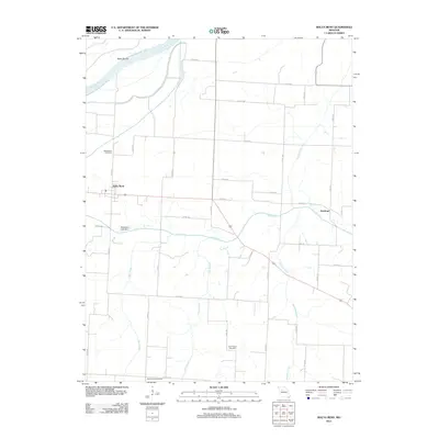
2012 Map of Malta Bend
USGS Topo · Published 2012About this map
Malta Bend and the surrounding agricultural lands of Saline County are defined by their proximity to the shifting channel of the Missouri River. The river's influence is evident in the Malta Bends terrain to the northwest, where the floodplain gives way to a network of creeks and branches that drain the interior. The landscape is primarily a grid of rural roads, including Co RD 417 and Co RD 421, which connect isolated farmsteads to the primary settlement at Malta Bend and the smaller locality of Stanhope.
Find a feature on this map
31 named features on this map. Tap any name to fly to it.
Don’t see what you’re looking for? This feature index may not catch every label — zoom into the map to look around manually.
Map Details
Editions of this 2012 Malta Bend Map
This is the sole edition of this map. No revisions or reprints were ever made.
Other maps of this area

1890 · Marshall
USGS Topo · 1:125,000

1892 · Marshall
USGS Topo · 1:125,000

1901 · Marshall
USGS Topo · 1:125,000

1940 · Marshall
USGS Topo · 1:62,500

1944 · Marshall
USGS Topo · 1:62,500

1951 · Miami
USGS Topo · 1:24,000

1951 · Miami Station
USGS Topo · 1:24,000

1951 · Carrollton East
USGS Topo · 1:24,000

1953 · Moberly
USGS Topo · 1:250,000
1953 · Blackburn
USGS Topo · 1:24,000