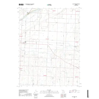
2017 Map of Malta Bend
USGS Topo · Published 2017About this map
Malta Bend and the surrounding agricultural lands of Saline County are defined by the winding course of the Missouri River as it passes the Malta Bends. The settlement pattern here reflects a long history of river-valley farming, with small communities like Stanhope connected by a network of rural roads such as N Saline Highway 65. The landscape is deeply dissected by numerous waterways, including the Salt Fork, Bear Cr, and Straddle Cr, which flow through the southern and eastern portions of the quadrangle.
Find a feature on this map
62 named features on this map. Tap any name to fly to it.
Don’t see what you’re looking for? This feature index may not catch every label — zoom into the map to look around manually.
Map Details
Editions of this 2017 Malta Bend Map
This is the sole edition of this map. No revisions or reprints were ever made.
Other maps of this area

1890 · Marshall
USGS Topo · 1:125,000

1892 · Marshall
USGS Topo · 1:125,000

1901 · Marshall
USGS Topo · 1:125,000

1940 · Marshall
USGS Topo · 1:62,500

1944 · Marshall
USGS Topo · 1:62,500

1951 · Miami
USGS Topo · 1:24,000

1951 · Miami Station
USGS Topo · 1:24,000

1951 · Carrollton East
USGS Topo · 1:24,000

1953 · Moberly
USGS Topo · 1:250,000
1953 · Blackburn
USGS Topo · 1:24,000