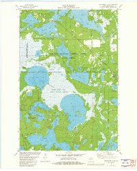
1981 Map of Manitowish Lake
USGS Topo · Published 1982About this map
The recreational and conservation landscape of northern Wisconsin is well-defined here, where the Northern Highland - American Legion State Forest meets the edge of the Lac du Flambeau Indian Reservation. The village of Manitowish Waters serves as the hub for a dense network of glacial lakes including Spider Lake, Island Lake, and the sprawling Manitowish Lake. This 1980s-era geography reflects a well-established seasonal economy, marked by locations such as Camp Nawakwa, East Camp Nawakwa, and Camp Wipigaki. Specialized land use is visible in the extensive Cranberry Bogs and the protected wetlands of the Powell Marsh State Public Hunting Grounds. The map documents local landmarks like Our Lady of the Lake Ch and Pine Lawn Cem, alongside transport infrastructure like the Manitowish Waters Airport and a system of named forest roads.
Find a feature on this map
70 named features on this map. Tap any name to fly to it.
Don’t see what you’re looking for? This feature index may not catch every label — zoom into the map to look around manually.
Map Details
Editions of this 1981 Manitowish Lake Map
This is the sole edition of this map. No revisions or reprints were ever made.
Other maps of this area

1938 · Minocqua
USGS Topo · 1:48,000

1938 · Lac Du Flambeau
USGS Topo · 1:48,000

1939 · Trout Lake
USGS Topo · 1:48,000

1939 · Lac Du Flambeau
USGS Topo · 1:48,000

1939 · Winchester
USGS Topo · 1:48,000

1946 · Winchester
USGS Topo · 1:48,000

1946 · Minocqua
USGS Topo · 1:48,000

1946 · Lac Du Flambeau
USGS Topo · 1:48,000

1946 · Trout Lake
USGS Topo · 1:48,000

1949 · Trout Lake
USGS Topo · 1:48,000