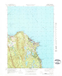
1977 Map of Manomet
USGS Topo · Published 1984About this map
Manomet serves as the inland anchor for this coastal stretch of Plymouth Hills, where the shoreline transitions from the wide expanse of Cape Cod Bay to the protected waters of Warren Cove. The landscape is defined by its maritime and agricultural heritage, notably the extensive network of Cranberry Bogs that fill the low-lying basins between Manomet Hill and Telegraph Hill. These bogs, alongside numerous kettle ponds like Fresh Pond and Island Pond, illustrate the distinct post-glacial hydrology of the South Shore.
Find a feature on this map
56 named features on this map. Tap any name to fly to it.
Don’t see what you’re looking for? This feature index may not catch every label — zoom into the map to look around manually.
Map Details
Editions of this 1977 Manomet Map
Other maps of this area

1885 · Duxbury
USGS Topo · 1:62,500

1886 · Plymouth
USGS Topo · 1:62,500

1888 · Duxbury
USGS Topo · 1:62,500

1889 · Plymouth
USGS Topo · 1:62,500

1893 · Duxbury
USGS Topo · 1:62,500

1894 · Plymouth
USGS Topo · 1:62,500

1918 · Duxbury
USGS Topo · 1:62,500
1921 · Plymouth
USGS Topo · 1:62,500
1933 · Sagamore
USGS Topo · 1:24,000
1934 · Plymouth
USGS Topo · 1:24,000
Featured Places
- Plymouth, MA
- Priscilla Beach, Plymouth
- Manomet Heights, Plymouth
- Churchill Landing, Plymouth
- Fishermans Landing, Plymouth