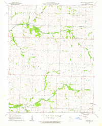
1962 Map of Maple Grove
USGS Topo · Published 1964About this map
The agricultural landscape of southwest Missouri is defined here by the intersection of Barton and Jasper counties, where a network of small creeks and rural institutions supported local farm families in the early 1960s. The settlement of Maple Grove sits in the southeast corner, while the surrounding townships of Sheridan, Lincoln, and Madison are dotted with landmarks vital to rural life. Social and spiritual centers like Zion Ch, Grace Ch, and the Pleasant View Community Center appear alongside the Spring Hill Sch, illustrating the dispersed but connected nature of this prairie community. The drainage of Coon Creek and its tributaries, including Little Coon Creek and Fox Branch, provides the primary topographic relief. For those tracing family roots, several burial grounds are recorded, including Mitchell Cem, Hackney Cem, and Pleasant View Cem.
Find a feature on this map
22 named features on this map. Tap any name to fly to it.
Don’t see what you’re looking for? This feature index may not catch every label — zoom into the map to look around manually.
Map Details
Editions of this 1962 Maple Grove Map
This is the sole edition of this map. No revisions or reprints were ever made.
Other maps of this area

1886 · Carthage
USGS Topo · 1:125,000

1894 · Carthage
USGS Topo · 1:125,000

1921 · Sarcoxie
USGS Topo · 1:62,500

1947 · Joplin
USGS Topo · 1:250,000

1949 · Joplin
USGS Topo · 1:250,000

1954 · Joplin
USGS Topo · 1:250,000

1958 · Joplin
USGS Topo · 1:250,000

1959 · Joplin
USGS Topo · 1:250,000
1962 · Kenoma
USGS Topo · 1:24,000
1962 · Jasper
USGS Topo · 1:24,000