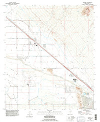
1992 Map of Marana
USGS Topo · Published 1995About this map
The Santa Cruz River defines the central corridor of this Pima County landscape, flowing through a region where desert agriculture and transportation infrastructure intersect. The town of Marana is prominently featured alongside the Marana (Siding), highlighting the historical importance of rail transit for this agricultural hub. To the southeast, the small settlement of Rillito sits near the riverbanks, anchored by industrial activity such as various Gravel Pits and proximity to the heavy-duty transit lines.
Find a feature on this map
30 named features on this map. Tap any name to fly to it.
Don’t see what you’re looking for? This feature index may not catch every label — zoom into the map to look around manually.
Map Details
Editions of this 1992 Marana Map
This is the sole edition of this map. No revisions or reprints were ever made.
Other maps of this area

1934 · Tucson Mountains
USGS Topo · 1:125,000

1934 · Newman Peak
USGS Topo · 1:125,000

1947 · Cortaro
USGS Topo · 1:62,500

1947 · Red Rock
USGS Topo · 1:62,500

1956 · Tucson
USGS Topo · 1:250,000

1957 · Cortaro
USGS Topo · 1:62,500

1958 · Tucson
USGS Topo · 1:250,000

1959 · Tucson
USGS Topo · 1:250,000

1959 · Tortolita Mts
USGS Topo · 1:62,500
1959 · Silver Bell Peak
USGS Topo · 1:62,500