
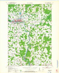
1953 Map of Marathon
USGS Topo · Published 1955About this map
Rib River and the Chicago and North Western railroad corridor define this central Wisconsin landscape during the mid-century. The village of Marathon and the town of Edgar serve as primary hubs, connected by a network of rural schoolhouses and parish centers that reveal the social structure of the era. Significant religious sites, such as the St Anthony Friary and several neighborhood cemeteries including Tessmer Cem and Hillside Sch Cem, highlight established community roots.
Find a feature on this map
58 named features on this map. Tap any name to fly to it.
Don’t see what you’re looking for? This feature index may not catch every label — zoom into the map to look around manually.
Map Details
Editions of this 1953 Marathon Map
This is the sole edition of this map. No revisions or reprints were ever made.
Other maps of this area

1899 · Wausau
USGS Topo · 1:125,000

1902 · Wausau
USGS Topo · 1:125,000

1902 · Marathon
USGS Topo · 1:125,000

1951 · Athens
USGS Topo · 1:48,000
1951 · Merrill
USGS Topo · 1:48,000

1951 · Hamburg
USGS Topo · 1:48,000

1953 · Wausau
USGS Topo · 1:48,000
1953 · Stratford
USGS Topo · 1:48,000

1953 · Eau Claire
USGS Topo · 1:250,000

1953 · Rice Lake
USGS Topo · 1:250,000