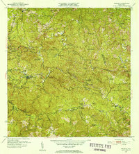
1952 Map of Maricao
USGS Topo · Published 1953About this map
The coffee-producing haciendas of western Puerto Rico dominate this 1952 landscape, reflecting an agricultural economy woven through the Cordillera Central. Named estates like Hacienda Lealtad, Hacienda Santa Rita, and Hacienda Esperanza serve as focal points for local history and genealogy, marking the legacy of the island's plantation system. The town of Maricao and its neighbor Pueblo Nuevo act as the central hubs for this territory, which is bounded by the Bosque Insular de Maricao.
Find a feature on this map
94 named features on this map. Tap any name to fly to it.
Don’t see what you’re looking for? This feature index may not catch every label — zoom into the map to look around manually.
Map Details
Editions of this 1952 Maricao Map
2 editions found
Other maps of this area

1937 · San German
USGS Topo · 1:25,000

1937 · Sabana Grande
USGS Topo · 1:25,000

1938 · Alto Sano
USGS Topo · 1:20,000

1938 · San Sebastian
USGS Topo · 1:20,000

1941 · San German
USGS Topo · 1:30,000

1941 · San Sebastian
USGS Topo · 1:30,000

1941 · Sabana Grande
USGS Topo · 1:30,000

1941 · Rosario
USGS Topo · 1:30,000

1942 · Central La Plata
USGS Topo · 1:30,000

1942 · Rosario
USGS Topo · 1:30,000