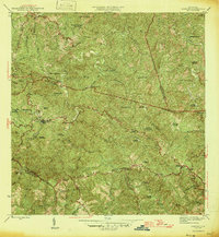
1946 Map of Maricao
USGS Topo · Published 1946About this map
Maricao and its surrounding mountain terrain are documented here just after the mid-century, revealing a landscape dominated by traditional coffee and agricultural estates. Numerous named haciendas, such as Hacienda Herencia, Hacienda Lealtad, and Hacienda Santa Rita, are scattered across the high ridges of the Cordillera Central. These estates, connected by winding mountain roads, define the economic and social structure of the region during this era, serving as the primary centers of population and production outside the main town centers of Maricao and Pueblo Nuevo.
Find a feature on this map
60 named features on this map. Tap any name to fly to it.
Don’t see what you’re looking for? This feature index may not catch every label — zoom into the map to look around manually.
Map Details
Editions of this 1946 Maricao Map
3 editions found

Other maps of this area

1937 · San German
USGS Topo · 1:25,000

1937 · Sabana Grande
USGS Topo · 1:25,000

1938 · Alto Sano
USGS Topo · 1:20,000

1938 · San Sebastian
USGS Topo · 1:20,000

1941 · San German
USGS Topo · 1:30,000

1941 · San Sebastian
USGS Topo · 1:30,000

1941 · Sabana Grande
USGS Topo · 1:30,000

1941 · Rosario
USGS Topo · 1:30,000

1942 · Central La Plata
USGS Topo · 1:30,000

1942 · Rosario
USGS Topo · 1:30,000