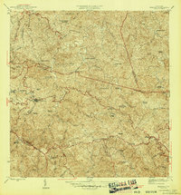
1946 Map of Maricao
USGS Topo · Published 1946About this map
The coffee-growing heart of Puerto Rico is revealed in this mid-1940s survey of the mountain town of Maricao. The landscape is dominated by the steep ridges of the Cordillera Central and the Sierra de Maricao, where a dense network of named haciendas illustrates the agricultural economy of the era. Settlements such as Pueblo Nuevo and family-named estates like Hacienda Lealtad and Hacienda Santa Rita are scattered across the interior. The presence of the Bosque Insular de Maricao in the southwest highlights the region's preserved forest lands, while rural life centers around landmarks like Iglesia de la Purisima and the Escuela Segunda Unidad de Bucarabones. This topographic record captures the transition of the highland municipal boundaries of Las Marias, Maricao, and San German before significant modern development altered the rural plantation patterns.
Find a feature on this map
58 named features on this map. Tap any name to fly to it.
Don’t see what you’re looking for? This feature index may not catch every label — zoom into the map to look around manually.
Map Details
Editions of this 1946 Maricao Map
3 editions found

Other maps of this area

1937 · San German
USGS Topo · 1:25,000

1937 · Sabana Grande
USGS Topo · 1:25,000

1938 · Alto Sano
USGS Topo · 1:20,000

1938 · San Sebastian
USGS Topo · 1:20,000

1941 · San German
USGS Topo · 1:30,000

1941 · San Sebastian
USGS Topo · 1:30,000

1941 · Sabana Grande
USGS Topo · 1:30,000

1941 · Rosario
USGS Topo · 1:30,000

1942 · Central La Plata
USGS Topo · 1:30,000

1942 · Rosario
USGS Topo · 1:30,000