
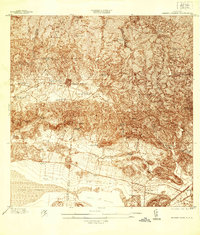
1937 Map of Sabana Grande
USGS Topo · Published 1937About this map
Sabana Grande serves as the focal point of this 1930s survey, situated where the southern foothills meet the productive Valle de Lajas. The landscape is defined by a dense network of rural schools, such as Escuela Manuel Fernandez Juncos and Escuela Carlota Matienzo, reflecting a period of significant educational investment in the island's interior. Along the valley floor, the American Railroad Company of Puerto Rico connects key points like Estacion La Plata and Estacion Limon, facilitating the transport of agricultural goods toward the coast.
Find a feature on this map
57 named features on this map. Tap any name to fly to it.
Don’t see what you’re looking for? This feature index may not catch every label — zoom into the map to look around manually.
Map Details
Editions of this 1937 Sabana Grande Map
2 editions found
Other maps of this area

1937 · San German
USGS Topo · 1:25,000

1938 · Guanica
USGS Topo · 1:30,000

1938 · Parguera
USGS Topo · 1:30,000

1941 · San German
USGS Topo · 1:30,000

1941 · Sabana Grande
USGS Topo · 1:30,000

1941 · Rosario
USGS Topo · 1:30,000

1942 · Rosario
USGS Topo · 1:30,000

1946 · Maricao
USGS Topo · 1:30,000

1946 · Yauco
USGS Topo · 1:30,000

1946 · Monte Guilarte
USGS Topo · 1:30,000
Featured Places
- Sabana Grande
- Sector Río Loco, Yauco
- Sector El Puente, Sabana Grande
- Sector Papayo, Sabana Grande
- Sector Facio, Yauco